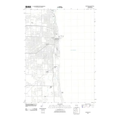
2010 Map of Kenosha
USGS Topo · Published 2010About this map
Kenosha sits prominently on the western shore of Lake Michigan, showing a dense urban grid that transitions into southern coastal developments. The city's maritime identity is anchored by landmarks like the Kenosha Light and South Pier Light, which guard the harbor entrance near the Kenosha Water Works and Villa Marina Docks. Inland, the landscape is defined by the winding course of the Pike River and the smaller Pike Creek, alongside a series of established burial grounds including B'nai Zedek Cemetery, Saint George Cemetery, and Greenridge Cemetery. A shift in infrastructure is evident in the presence of the Kenosha County Bike Trl, reflecting the repurposing of transportation corridors. Further south, distinct residential pockets such as Shorecrest Pointe, Timber Ridge, and Carol Beach line the lakefront, ending near the settlement of Tobin as the shoreline continues toward the state border.
Find a feature on this map
40 named features on this map. Tap any name to fly to it.
Don’t see what you’re looking for? This feature index may not catch every label — zoom into the map to look around manually.
Map Details
Editions of this 2010 Kenosha Map
This is the sole edition of this map. No revisions or reprints were ever made.
Other maps of this area

1892 · Racine
USGS Topo · 1:62,500

1905 · Racine
USGS Topo · 1:62,500

1906 · Waukegan
USGS Topo · 1:62,500

1908 · Waukegan
USGS Topo · 1:62,500

1958 · Kenosha
USGS Topo · 1:24,000

1958 · Racine South
USGS Topo · 1:24,000

1958 · Pleasant Prairie
USGS Topo · 1:24,000

1958 · Racine
USGS Topo · 1:250,000

1959 · Racine
USGS Topo · 1:62,500

1959 · Sturtevant
USGS Topo · 1:24,000