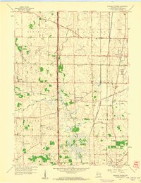
1958 Map of Pleasant Prairie
USGS Topo · Published 1960About this map
The Des Plaines River winds through the heart of this agricultural and aviation landscape in Kenosha County during the late 1950s. The map illustrates a transitional period for the township of Pleasant Prairie, where established farming communities exist alongside the growing Kenosha Airport. Local education and faith are deeply rooted in the terrain, evidenced by numerous rural institutions such as Star Harmony Sch, Hazel Dell Sch, and the Wesley Ch.
Find a feature on this map
31 named features on this map. Tap any name to fly to it.
Don’t see what you’re looking for? This feature index may not catch every label — zoom into the map to look around manually.
Map Details
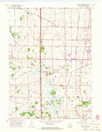
Editions of this 1958 Pleasant Prairie Map
2 editions found
Other maps of this area

1892 · Racine
USGS Topo · 1:62,500

1893 · Silver Lake
USGS Topo · 1:62,500

1905 · Racine
USGS Topo · 1:62,500

1906 · Silver Lake
USGS Topo · 1:62,500

1906 · Waukegan
USGS Topo · 1:62,500

1908 · Waukegan
USGS Topo · 1:62,500

1920 · Grays Lake
USGS Topo · 1:62,500

1923 · Grays Lake
USGS Topo · 1:62,500

1954 · Rockford
USGS Topo · 1:250,000

1955 · Rockford
USGS Topo · 1:250,000