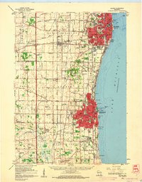
1959 Map of Racine
USGS Topo · Published 1960About this map
Lake Michigan forms the eastern edge of this late-1950s landscape, where the urban grids of Racine and Kenosha transition into a dense network of dairy farms and rural school districts. The region is defined by a heavy concentration of small, named schools such as Herzog Sch and Bullamore Forks Sch, serving established communities like Somers and Pleasant Prairie. Rail infrastructure dominates the interior, with the Chicago North Shore and Milwaukee and the Chicago and North Western lines facilitating the transport of goods and people between the lakeside industrial hubs. Inland, specialized facilities like the Sunny Rest Sanatorium and the Kenosha Airport reflect the mid-century expansion of public services and aviation. Waterways like the Root River and Pike River wind through the terrain, passing through recreational areas like Petrifying Springs Park and reaching the lake near landmarks like the Waterworks Intake.
Find a feature on this map
105 named features on this map. Tap any name to fly to it.
Don’t see what you’re looking for? This feature index may not catch every label — zoom into the map to look around manually.
Map Details
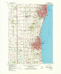
Editions of this 1959 Racine Map
2 editions found
Other maps of this area

1891 · Bayview
USGS Topo · 1:62,500

1891 · Muskego
USGS Topo · 1:62,500

1892 · Racine
USGS Topo · 1:62,500

1893 · Silver Lake
USGS Topo · 1:62,500

1901 · Bayview
USGS Topo · 1:62,500

1901 · Muskego
USGS Topo · 1:62,500

1905 · Racine
USGS Topo · 1:62,500

1906 · Silver Lake
USGS Topo · 1:62,500

1906 · Waukegan
USGS Topo · 1:62,500

1908 · Waukegan
USGS Topo · 1:62,500