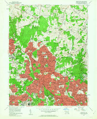
1956 Map of Kensington
USGS Topo · Published 1963About this map
Rock Creek carves a deep valley through this mid-century landscape, separating the residential growth of Kensington and Rockville from the wooded tracts of Manor Park and Norbeck. The era's expansion is evident in the dense street grids of Randolph Hills and Franklin Park, contrasting with the more traditional estates at Bel Pre Farms and Gayfields. This mid-1950s survey captures a significant institutional presence in Montgomery County, showcasing sprawling campuses for the National Institutes of Health and the Naval Medical Center near the southern boundary.
Find a feature on this map
210 named features on this map. Tap any name to fly to it.
Don’t see what you’re looking for? This feature index may not catch every label — zoom into the map to look around manually.
Map Details
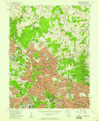
Editions of this 1956 Kensington Map
2 editions found
Other maps of this area

1890 · Mt. Vernon
USGS Topo · 1:125,000

1891 · Mt. Vernon
USGS Topo · 1:125,000

1892 · Laurel
USGS Topo · 1:62,500

1893 · Frederick
USGS Topo · 1:125,000

1894 · Laurel
USGS Topo · 1:62,500

1894 · Frederick
USGS Topo · 1:125,000

1894 · Mt. Vernon
USGS Topo · 1:125,000

1897 · Laurel
USGS Topo · 1:62,500

1897 · Mt. Vernon
USGS Topo · 1:125,000

1899 · Patuxent
USGS Topo · 1:125,000