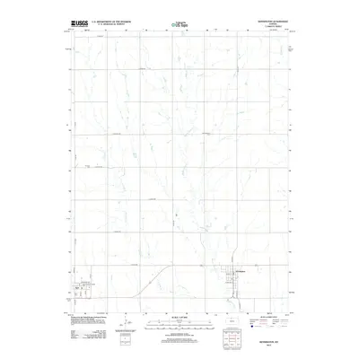
2012 Map of Kensington
USGS Topo · Published 2012About this map
Kensington and Agra anchor this portrait of Smith County agriculture in the early twenty-first century, showing the enduring grid of section-line roads and the hydrology of the Cedar Creek system. The landscape is defined by the north-south flow of Middle Cedar Cr, W Cedar Cr, and E Cedar Cr, which cut through the high plains terrain. Local heritage is centered around small civic nodes and communal grounds such as Germantown, the Agra American Legion Hall, and several local burial sites including Agra Cem, Germantown Cem, and W Cedar Cem. The map preserves the street-level detail of these rural communities, from Railroad Ave in Agra to the intersection of N Main St and W Pine St in Kensington. This arrangement reflects a century of Kansas plains settlement where grain transit and local commerce dictated the placement of every depot and town square.
Find a feature on this map
32 named features on this map. Tap any name to fly to it.
Don’t see what you’re looking for? This feature index may not catch every label — zoom into the map to look around manually.
Map Details
Editions of this 2012 Kensington Map
This is the sole edition of this map. No revisions or reprints were ever made.
Other maps of this area

1893 · Smith Center
USGS Topo · 1:125,000

1893 · Phillipsburg
USGS Topo · 1:125,000

1955 · Beloit
USGS Topo · 1:250,000

1959 · Beloit
USGS Topo · 1:250,000

1972 · Kirwin
USGS Topo · 1:24,000

1972 · Kirwin Reservoir
USGS Topo · 1:24,000

1973 · Kensington
USGS Topo · 1:24,000

1973 · Athol
USGS Topo · 1:24,000

1973 · Kensington NE
USGS Topo · 1:24,000
1973 · Cedar
USGS Topo · 1:24,000