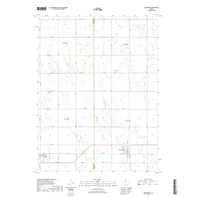
2018 Map of Kensington
USGS Topo · Published 2018About this map
Kensington and Agra serve as the primary anchors of this Smith County landscape, positioned along the southern corridor of the quadrangle. The map captures a quintessential Kansas agricultural grid, where the Phillips Co Smith Co line divides the territory and a dense network of numbered and named section roads—ranging from E Jade Rd in the north to E Ridge Rd in the south—connects isolated homesteads. The hydrography is dominated by the branches of Cedar Creek, including Middle Cedar Cr and W Cedar Cr, which carve subtle drainage patterns across the plains.
Find a feature on this map
35 named features on this map. Tap any name to fly to it.
Don’t see what you’re looking for? This feature index may not catch every label — zoom into the map to look around manually.
Map Details
Editions of this 2018 Kensington Map
This is the sole edition of this map. No revisions or reprints were ever made.
Other maps of this area

1893 · Smith Center
USGS Topo · 1:125,000

1893 · Phillipsburg
USGS Topo · 1:125,000

1955 · Beloit
USGS Topo · 1:250,000

1959 · Beloit
USGS Topo · 1:250,000

1972 · Kirwin
USGS Topo · 1:24,000

1972 · Kirwin Reservoir
USGS Topo · 1:24,000

1973 · Kensington
USGS Topo · 1:24,000

1973 · Athol
USGS Topo · 1:24,000

1973 · Kensington NE
USGS Topo · 1:24,000
1973 · Cedar
USGS Topo · 1:24,000