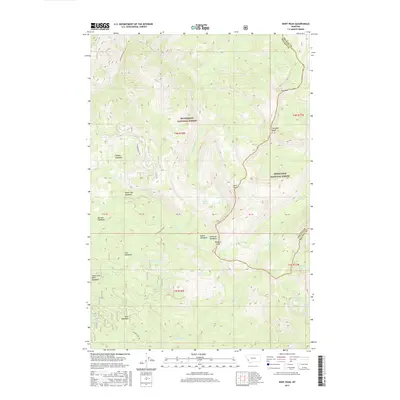
2017 Map of Kent Peak
USGS Topo · Published 2017About this map
Kent Peak and Fox Peak define the high ridgelines of this Montana landscape, where the Bitterroot National Forest meets the Deerlodge National Forest along the Granite and Ravalli County line. This 2017 survey details a high-elevation backcountry network of named meadows and alpine lakes, including the distinctive Gods Little Acre Meadows and Lake Abundance. The terrain is drained by several prominent headwaters, notably Skalkaho Cr and the Ross Fork of the Rock Creek drainage. Navigational access is shown via the Skalkaho Rye Rd, which winds through the western half of the quadrangle near Coyote Meadows and Barnett Meadows. This modern topographic record is essential for tracing the specific hydrology and named landmarks of the Sapphire Mountains, from the Rooster Comb formation to secluded waters like Shadow Lake and Faith Lake.
Find a feature on this map
42 named features on this map. Tap any name to fly to it.
Don’t see what you’re looking for? This feature index may not catch every label — zoom into the map to look around manually.
Map Details
Editions of this 2017 Kent Peak Map
This is the sole edition of this map. No revisions or reprints were ever made.
Other maps of this area

1909 · Sapphire
USGS Topo · 1:125,000

1947 · Butte
USGS Topo · 1:250,000

1955 · Dillon
USGS Topo · 1:250,000

1957 · Dillon
USGS Topo · 1:250,000

1958 · Butte
USGS Topo · 1:250,000

1958 · Dillon
USGS Topo · 1:250,000

1960 · Butte
USGS Topo · 1:250,000

1962 · Butte
USGS Topo · 1:250,000

1962 · Dillon
USGS Topo · 1:250,000

1965 · Dillon
USGS Topo · 1:250,000