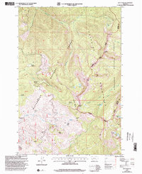
1998 Map of Kent Peak
USGS Topo · Published 2002About this map
The Sapphire Mountains define the high country on this 1990s survey, where the boundary between Bitterroot National Forest and Deerlodge National Forest follows the ridgeline. This landscape is marked by a series of high-altitude meadows and summits, including Kent Peak and the distinctive Rooster Comb. Human presence is minimal in this wilderness area, centered on the Lost Tooth Cabin near the headwaters of Martin Creek. The map details a complex network of forest management boundaries, including the Darby Philipsburg Ranger District and Philipsburg Sula Ranger District. A cluster of small alpine lakes, such as Hope Lake, Faith Lake, and Charity Lake, sits tucked into the eastern slopes, while the western drainage flows into Sleeping Child Creek and Skalkaho Creek.
Find a feature on this map
36 named features on this map. Tap any name to fly to it.
Don’t see what you’re looking for? This feature index may not catch every label — zoom into the map to look around manually.
Map Details
Editions of this 1998 Kent Peak Map
This is the sole edition of this map. No revisions or reprints were ever made.
Other maps of this area

1909 · Sapphire
USGS Topo · 1:125,000

1947 · Butte
USGS Topo · 1:250,000

1955 · Dillon
USGS Topo · 1:250,000

1957 · Dillon
USGS Topo · 1:250,000

1958 · Butte
USGS Topo · 1:250,000

1958 · Dillon
USGS Topo · 1:250,000

1960 · Butte
USGS Topo · 1:250,000

1962 · Butte
USGS Topo · 1:250,000

1962 · Dillon
USGS Topo · 1:250,000

1965 · Dillon
USGS Topo · 1:250,000