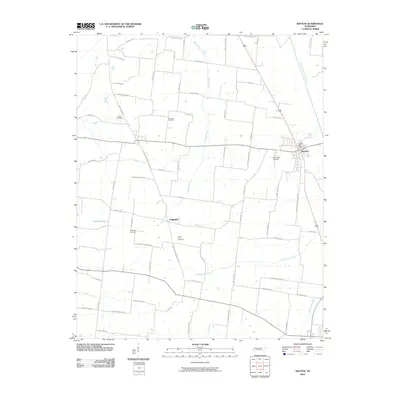
2010 Map of Kenton
USGS Topo · Published 2010About this map
The town of Kenton and the surrounding agricultural lands of Rutherford and Gibson County are documented here as they appeared in 2010. The landscape is defined by the Rutherford Fork Obion River on the eastern edge and several smaller waterways like Grass Creek and Edmundson Creek that drain the local fields. For genealogists and local historians, the sheet preserves the locations of several burial grounds, including Salem Cemetery, Hollomon Cemetery, and the North Union Cemetery near the community of Fairview. The transport network shows a high density of rural routes named for local families, such as Larry Finch Rd, Brentz Moore Rd, and Roger Newman Rd, suggesting deep generational ties to the land. The presence of the Kenton Post Office and Sunny Side Cemetery further anchor this West Tennessee community's layout at the start of the 21st century.
Find a feature on this map
72 named features on this map. Tap any name to fly to it.
Don’t see what you’re looking for? This feature index may not catch every label — zoom into the map to look around manually.
Map Details
Editions of this 2010 Kenton Map
This is the sole edition of this map. No revisions or reprints were ever made.
Other maps of this area

1950 · Obion
USGS Topo · 1:24,000

1950 · Rives
USGS Topo · 1:24,000

1951 · Obion
USGS Topo · 1:24,000

1951 · Rives
USGS Topo · 1:24,000

1953 · Dyer
USGS Topo · 1:24,000

1954 · Rutherford
USGS Topo · 1:24,000

1956 · Gardner
USGS Topo · 1:24,000

1956 · Dyersburg
USGS Topo · 1:250,000
1964 · Yorkville
USGS Topo · 1:24,000
1965 · Kenton
USGS Topo · 1:24,000