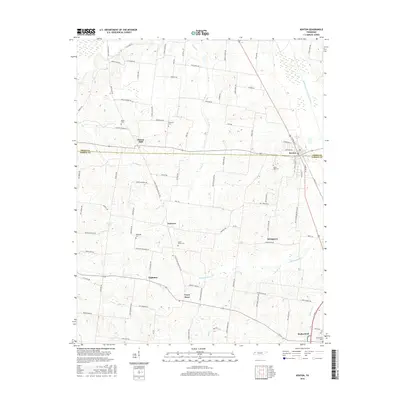
2016 Map of Kenton
USGS Topo · Published 2016About this map
The boundary between Obion Co and Gibson Co bisects the agricultural landscape of West Tennessee, where the town of Kenton serves as a central hub. This survey illustrates a resilient rural settlement pattern of small communities such as Fairview, Tilghman, and Stringtown, many of which grew around crossroads and local commerce points like Tyson Store. The terrain is shaped by the Rutherford Fork Obion River and its various tributaries including Grass Cr, Bamboo Cr, and Edmundson Cr, which create the low-lying drainage basins characteristic of the region.
Find a feature on this map
96 named features on this map. Tap any name to fly to it.
Don’t see what you’re looking for? This feature index may not catch every label — zoom into the map to look around manually.
Map Details
Editions of this 2016 Kenton Map
This is the sole edition of this map. No revisions or reprints were ever made.
Other maps of this area

1950 · Obion
USGS Topo · 1:24,000

1950 · Rives
USGS Topo · 1:24,000

1951 · Obion
USGS Topo · 1:24,000

1951 · Rives
USGS Topo · 1:24,000

1953 · Dyer
USGS Topo · 1:24,000

1954 · Rutherford
USGS Topo · 1:24,000

1956 · Gardner
USGS Topo · 1:24,000

1956 · Dyersburg
USGS Topo · 1:250,000
1964 · Yorkville
USGS Topo · 1:24,000
1965 · Kenton
USGS Topo · 1:24,000