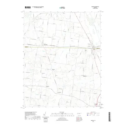
2019 Map of Kenton
USGS Topo · Published 2019About this map
Kenton and Rutherford anchor this West Tennessee landscape along the Obion and Gibson County line. The terrain is defined by the drainage network of the Rutherford Fork Obion River and its various tributaries like Grass Cr and Edmundson Cr, which carve through the agricultural uplands. Settlement patterns here remain centered around rural crossroads and established family landmarks, including several rural burial grounds such as Sunny Side Cem and North Union Cem. The survey highlights the endurance of small communities like Mason Hall, Tilhman, and Tyson Store, connected by a network of local routes including the Old Turnpike Rd. These features illustrate the persistent rural character of the region, where land use is dictated by the proximity to water sources like Bamboo Cr and the larger river system to the east.
Find a feature on this map
102 named features on this map. Tap any name to fly to it.
Don’t see what you’re looking for? This feature index may not catch every label — zoom into the map to look around manually.
Map Details
Editions of this 2019 Kenton Map
This is the sole edition of this map. No revisions or reprints were ever made.
Other maps of this area

1950 · Obion
USGS Topo · 1:24,000

1950 · Rives
USGS Topo · 1:24,000

1951 · Obion
USGS Topo · 1:24,000

1951 · Rives
USGS Topo · 1:24,000

1953 · Dyer
USGS Topo · 1:24,000

1954 · Rutherford
USGS Topo · 1:24,000

1956 · Gardner
USGS Topo · 1:24,000

1956 · Dyersburg
USGS Topo · 1:250,000
1964 · Yorkville
USGS Topo · 1:24,000
1965 · Kenton
USGS Topo · 1:24,000