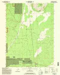
1993 Map of Kephart
USGS Topo · Published 1996About this map
Modoc National Forest dominates this high-altitude landscape, where the Doublehead Big Valley Ranger District manages a complex of timber and wildlife resources. The map documents a transition from the volcanic elevations of Timber Mountain in the northeast down toward the protected habitats of the Long Bell State Game Refuge in the southwest. Settlement is sparse, represented by the namesake Kephart and the Timber Mtn Ranch, reflecting the region's focus on ranching and forestry rather than urban development.
Find a feature on this map
22 named features on this map. Tap any name to fly to it.
Don’t see what you’re looking for? This feature index may not catch every label — zoom into the map to look around manually.
Map Details
Editions of this 1993 Kephart Map
This is the sole edition of this map. No revisions or reprints were ever made.
Other maps of this area

1886 · Modoc Lava Bed
USGS Topo · 1:250,000

1892 · Modoc Lava-Bed
USGS Topo · 1:250,000

1952 · Timber Mountain
USGS Topo · 1:62,500

1952 · Hackamore
USGS Topo · 1:62,500

1954 · Alturas
USGS Topo · 1:250,000

1958 · Alturas
USGS Topo · 1:250,000

1962 · Alturas
USGS Topo · 1:250,000

1962 · Crank Mountain
USGS Topo · 1:62,500

1962 · White Horse
USGS Topo · 1:62,500

1965 · Alturas
USGS Topo · 1:250,000