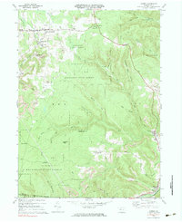
1970 Map of Kersey
USGS Topo · Published 1983About this map
Extensive mining operations define the landscape between Kersey and Byrnedale in this northern Pennsylvania survey. Numerous Strip Mine locations are documented across the plateaus, particularly surrounding Dagus Mines and near Coal Hollow, illustrating the industrial footprint on the region's geography. These operations are situated amidst the wooded reaches of Moshannon State Forest and Elk State Forest, where the topography is cut by deep drainage basins like Little Toby Creek and Hymick Run.
Find a feature on this map
54 named features on this map. Tap any name to fly to it.
Don’t see what you’re looking for? This feature index may not catch every label — zoom into the map to look around manually.
Map Details
Editions of this 1970 Kersey Map
3 editions found
Other maps of this area

1929 · Clearfield
USGS Topo · 1:48,000

1929 · Penfield
USGS Topo · 1:62,500

1932 · Clearfield
USGS Topo · 1:62,500

1932 · Penfield
USGS Topo · 1:62,500

1941 · Benezette
USGS Topo · 1:62,500

1941 · Ridgway
USGS Topo · 1:62,500

1943 · Benezette
USGS Topo · 1:62,500

1944 · Ridgway
USGS Topo · 1:62,500

1957 · Warren
USGS Topo · 1:250,000

1958 · Warren
USGS Topo · 1:250,000
Featured Places
- Fox Township, PA
- Coal Hollow, Fox Township
- Kersey, Fox Township
- Dagus Mines, Fox Township
- Jay Township, PA