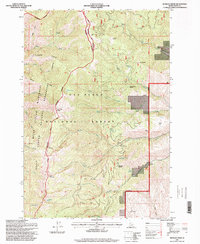
1995 Map of Kessler Creek
USGS Topo · Published 1999About this map
The Nez Perce National Forest and Hells Canyon National Recreation Area converge in this high-altitude landscape, where the Wilderness Boundary marks a transition into some of the region's most secluded terrain. Resource extraction is evidenced by the Spotted Horse Mine near Grave Creek and the Old Timer Mine further west. The topography is defined by sharp ridges like Clarks Ridge and McClinery Ridge, while the Boise Meridian serves as a primary survey reference. Named for specific local figures or landmarks, sites such as Boodry Place and Hiltsley Flat provide specific points of interest for genealogists and local historians tracking the sparse human footprint in this mountainous interior. Water is central to the landscape, from the alpine Crater Lake and Papoose Lake to the drainage networks of Race Creek and Squaw Creek.
Find a feature on this map
47 named features on this map. Tap any name to fly to it.
Don’t see what you’re looking for? This feature index may not catch every label — zoom into the map to look around manually.
Map Details
Editions of this 1995 Kessler Creek Map
This is the sole edition of this map. No revisions or reprints were ever made.
Other maps of this area

1922 · He Devil
USGS Topo · 1:48,000

1938 · Riggins
USGS Topo · 1:96,000

1945 · Riggins
USGS Topo · 1:125,000

1954 · Kernan Point
USGS Topo · 1:62,500

1955 · Grangeville
USGS Topo · 1:250,000

1957 · He Devil
USGS Topo · 1:62,500

1959 · Grangeville
USGS Topo · 1:250,000

1963 · Lucile
USGS Topo · 1:24,000

1963 · Kirkwood Creek
USGS Topo · 1:24,000

1964 · Riggins
USGS Topo · 1:24,000