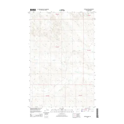
2014 Map of Kester School
USGS Topo · Published 2014About this map
Kester School stands as a lonely landmark in this high plains landscape of eastern Garfield County. The terrain is defined by the Piney Buttes to the north and an intricate network of drainage systems, including Crooked Cr and its eastern fork, which carve through the land. The presence of Buffalo Hill Reservoir near the center of the map indicates the critical importance of water management in this arid ranching country. Transportation is sparse, anchored by MT-341 and a few private routes like John Ln. The map also traces the headwaters of the Woody Cr system, with its north and south forks winding through the township and range boundaries. This survey documents the persistent but thin footprint of human activity, where a single schoolhouse and a scattered irrigation project serve as primary geographic anchors for the surrounding grazing lands.
Find a feature on this map
19 named features on this map. Tap any name to fly to it.
Don’t see what you’re looking for? This feature index may not catch every label — zoom into the map to look around manually.
Map Details
Editions of this 2014 Kester School Map
This is the sole edition of this map. No revisions or reprints were ever made.
Other maps of this area

1954 · Jordan
USGS Topo · 1:250,000

1956 · Jordan
USGS Topo · 1:250,000

1958 · Jordan
USGS Topo · 1:250,000

1958 · Maloney Hill
USGS Topo · 1:62,500

1964 · Jordan
USGS Topo · 1:250,000

1964 · Jordan NE
USGS Topo · 1:24,000

1964 · Bateman Coulee
USGS Topo · 1:24,000

1964 · Bateman Coulee NE
USGS Topo · 1:24,000
1972 · Kester School
USGS Topo · 1:24,000
1972 · Gilbert Creek SE
USGS Topo · 1:24,000