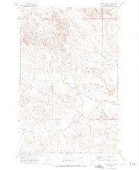
1972 Map of Kester School
USGS Topo · Published 1975About this map
Kester School serves as a central landmark in this remote corner of Garfield County, marking a landscape defined by an intricate network of seasonal drainage forks. The terrain is shaped by the headwaters of several systems, including Crooked Creek to the northwest and the winding paths of North Fork Woody Creek and South Fork Woody Creek to the southeast. Settled activity is concentrated along the Haxby Road, which provides the primary artery through the hills, connecting isolated outposts like the Binion Ranch. This 1970s survey illustrates the sparse, ranch-oriented development of the Montana interior, where small landing strips like the Landing Area and infrastructure such as the Radio Tower are essential for communication and travel across the expansive breaks.
Find a feature on this map
16 named features on this map. Tap any name to fly to it.
Don’t see what you’re looking for? This feature index may not catch every label — zoom into the map to look around manually.
Map Details
Editions of this 1972 Kester School Map
This is the sole edition of this map. No revisions or reprints were ever made.
Other maps of this area

1954 · Jordan
USGS Topo · 1:250,000

1956 · Jordan
USGS Topo · 1:250,000

1958 · Jordan
USGS Topo · 1:250,000

1958 · Maloney Hill
USGS Topo · 1:62,500

1964 · Jordan
USGS Topo · 1:250,000

1964 · Jordan NE
USGS Topo · 1:24,000

1964 · Bateman Coulee
USGS Topo · 1:24,000

1964 · Bateman Coulee NE
USGS Topo · 1:24,000
1972 · Gilbert Creek SE
USGS Topo · 1:24,000
1972 · Gilbert Creek
USGS Topo · 1:24,000