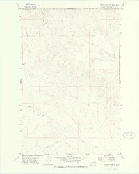
1972 Map of Gilbert Creek SE
USGS Topo · Published 1975About this map
Haxby Road serves as the primary artery through this section of Garfield County, Montana, providing a connection through a landscape defined by an intricate network of drainages. The topography is shaped by the descent of water toward the Missouri River system, with prominent features including the winding path of Woody Creek and Flat Creek. In the southeastern portion of the map, Redbank Coulee carves through the terrain, while the northern reaches are defined by the upper courses of Gilbert Creek. A small, unnamed Landing Area and scattered Well sites hint at the light human footprint in this vast grazing and ranching country. The transition between the high flats and the dissected breaks reveals a complex pattern of erosion and water management essential for survival in the eastern Montana plains during the early 1970s.
Find a feature on this map
10 named features on this map. Tap any name to fly to it.
Don’t see what you’re looking for? This feature index may not catch every label — zoom into the map to look around manually.
Map Details
Editions of this 1972 Gilbert Creek SE Map
This is the sole edition of this map. No revisions or reprints were ever made.
Other maps of this area

1954 · Jordan
USGS Topo · 1:250,000

1956 · Jordan
USGS Topo · 1:250,000

1958 · Jordan
USGS Topo · 1:250,000

1964 · Jordan
USGS Topo · 1:250,000

1964 · Bateman Coulee
USGS Topo · 1:24,000

1964 · Bateman Coulee NE
USGS Topo · 1:24,000

1967 · Hagen Gap
USGS Topo · 1:24,000
1972 · Kester School
USGS Topo · 1:24,000

1972 · Flat Creek School
USGS Topo · 1:24,000
1972 · Gilbert Creek
USGS Topo · 1:24,000