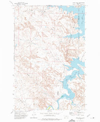
1972 Map of Flat Creek School
USGS Topo · Published 1975About this map
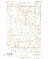
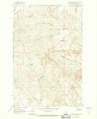
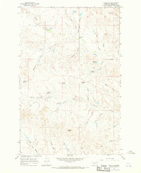
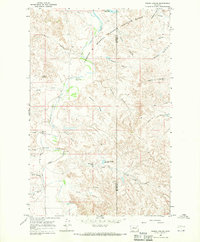
Flat Creek Sch stands as a focal point in this remote corner of Garfield County, marking a landscape defined by ranching and intermittent watercourses. In the early 1970s, the terrain was characterized by a network of drainage features like Green Coulee and Thompson Coulee, which carve through the high plains. The area shows evidence of light industrial and agricultural activity, from the Viall Pit and scattered Drill Hole locations to the established Twitchell Ranch. Seasonal waterways such as Lone Tree Creek, Snap Creek, and the primary Flat Creek dictate the local geography, suggesting a reliance on the sparse water resources available in this high prairie environment. The map captures the vast township-and-range grid system, with various Well sites and fence lines indicating the reach of private landholdings across the drainage of Arnold Coulee.
Find a feature on this map
15 named features on this map. Tap any name to fly to it.
Don’t see what you’re looking for? This feature index may not catch every label — zoom into the map to look around manually.
Map Details
Editions of this 1972 Flat Creek School Map
This is the sole edition of this map. No revisions or reprints were ever made.
Other maps of this area

1954 · Jordan
USGS Topo · 1:250,000

1956 · Jordan
USGS Topo · 1:250,000

1958 · Jordan
USGS Topo · 1:250,000

1964 · Jordan
USGS Topo · 1:250,000
1964 · Bateman Coulee NE
USGS Topo · 1:24,000
1967 · Hagen Gap
USGS Topo · 1:24,000
1967 · Frank Coulee
USGS Topo · 1:24,000
1972 · Short Creek
USGS Topo · 1:24,000
1972 · Gilbert Creek SE
USGS Topo · 1:24,000
1972 · Gilbert Creek
USGS Topo · 1:24,000