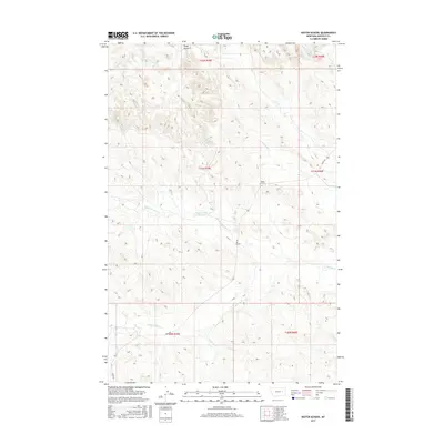
2017 Map of Kester School
USGS Topo · Published 2017About this map
Kester School sits at the heart of this rangeland in Garfield County, serving as a rare focal point for a remote ranching community. The landscape is defined by the high ground of the Piney Buttes and a branching network of seasonal drainages, including Crooked Cr and Pass Cr. Water management is critical in this arid environment, illustrated by the Buffalo Hill Reservoir and the divergent flows of N-Fork Woody Cr and S Fork Woody Cr. The map reveals the isolation of this corner of Montana, where Haxby Rd provides the primary transit artery across the township and range lines. Researchers can trace the layout of early 21st-century cattle country, where land use is dictated by the rugged topography of the buttes and the availability of water at small reservoirs and creek forks.
Find a feature on this map
18 named features on this map. Tap any name to fly to it.
Don’t see what you’re looking for? This feature index may not catch every label — zoom into the map to look around manually.
Map Details
Editions of this 2017 Kester School Map
This is the sole edition of this map. No revisions or reprints were ever made.
Other maps of this area

1954 · Jordan
USGS Topo · 1:250,000

1956 · Jordan
USGS Topo · 1:250,000

1958 · Jordan
USGS Topo · 1:250,000

1958 · Maloney Hill
USGS Topo · 1:62,500

1964 · Jordan
USGS Topo · 1:250,000

1964 · Jordan NE
USGS Topo · 1:24,000

1964 · Bateman Coulee
USGS Topo · 1:24,000

1964 · Bateman Coulee NE
USGS Topo · 1:24,000
1972 · Kester School
USGS Topo · 1:24,000
1972 · Gilbert Creek SE
USGS Topo · 1:24,000