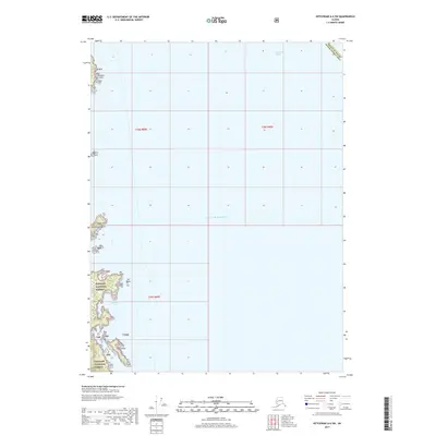
2017 Map of Ketchikan A-6 SW
USGS Topo · Published 2017About this map
The Tongass National Forest dominates the coastal margins of this maritime landscape in the Prince of Wales-Hyder Census Area. This coastal survey centers on the transition from the Gulf of Alaska into the protected waters of the Clarence Strait. The rugged shoreline is defined by numerous maritime landmarks including Adams Point in the north and the jagged outcrops of Sun Rocks further south. The map provides a precise view of the Alexander Archipelago's intricate coastline, featuring islands such as Polk Island and Whiterock Island. These features, alongside Chichagof Bay and Moira Rock, document the navigational hazards and natural harbor formations as they existed in the early 21st century. The map also delineates the legal boundaries of the Prince of Wales-Hyder Census Area, anchoring these geological features within their modern administrative context.
Find a feature on this map
15 named features on this map. Tap any name to fly to it.
Don’t see what you’re looking for? This feature index may not catch every label — zoom into the map to look around manually.
Map Details
Editions of this 2017 Ketchikan A-6 SW Map
This is the sole edition of this map. No revisions or reprints were ever made.
Other maps of this area

1948 · Prince Rupert D-6
USGS Topo · 1:63,360

1948 · Ketchikan A-6
USGS Topo · 1:63,360

1948 · Craig A-1
USGS Topo · 1:63,360

1948 · Dixon Entrance D-1
USGS Topo · 1:63,360

1951 · Prince Rupert
USGS Topo · 1:250,000

1951 · Dixon Entrance
USGS Topo · 1:250,000

1951 · Prince Rupert D-6
USGS Topo · 1:63,360

1952 · Ketchikan
USGS Topo · 1:250,000

1955 · Ketchikan
USGS Topo · 1:250,000

1957 · Craig
USGS Topo · 1:250,000