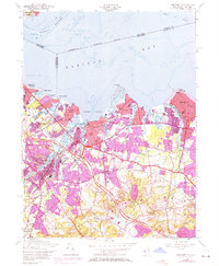
1954 Map of Keyport
USGS Topo · Published 1972About this map
The Monmouth County coastline along Raritan Bay is defined by its deep-water access and established rail corridors during this mid-century period. Industrial and maritime activity centers on Keyport Harbor, where the Central Railroad of New Jersey reaches the waterfront near several boat slips and piers. Further inland, the map shows the transition from the densely settled boroughs of Keyport and Matawan to the agricultural and clay-rich lands of Holmdel and Marlboro. A significant feature of the local economy is recorded at the clay pit near Cliffwood, a nod to the region's historic brick-making industry. This edition also documents the early footprint of the Garden State Parkway as it began to reshape suburban transit patterns across the bayshore. Family history is well-represented through numerous named intersections like Van Marters Corner and local burial grounds such as St Josephs Cem and Rose Hill Cem.
Find a feature on this map
70 named features on this map. Tap any name to fly to it.
Don’t see what you’re looking for? This feature index may not catch every label — zoom into the map to look around manually.
Map Details
Editions of this 1954 Keyport Map
4 editions found
Other maps of this area

1888 · Plainfield
USGS Topo · 1:62,500

1888 · New Brunswick
USGS Topo · 1:62,500

1888 · Sandy Hook
USGS Topo · 1:62,500

1893 · New Brunswick
USGS Topo · 1:62,500

1893 · Plainfield
USGS Topo · 1:62,500

1893 · Sandy Hook
USGS Topo · 1:62,500

1898 · Plainfield
USGS Topo · 1:62,500

1898 · Staten Island
USGS Topo · 1:62,500

1900 · Passaic
USGS Topo · 1:125,000

1900 · Staten Island
USGS Topo · 1:62,500