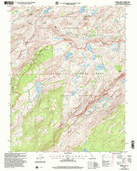
2001 Map of Kibbie Lake
USGS Topo · Published 2004About this map
Kibbie Lake and the high Sierra backcountry of Tuolumne County are documented here as they appeared at the turn of the millennium. This map straddles the boundary between Stanislaus National Forest and Yosemite National Park, capturing a landscape defined by glacial lakes and sharp granite ridges. The Emigrant Wilderness occupies the northern half, where Cherry Creek and its many tributaries, including Kendrick Creek and Bartlett Creek, have carved deep canyons through the batholith. A single human structure, the Sachse Ranger Cabin, sits near Sachse Springs on the western flank of Kibbie Ridge, providing a rare point of reference in this protected wilderness. The map is particularly dense with alpine water bodies such as Yellowhammer Lake, Hyatt Lake, and Spotted Fawn Lake, illustrating the complex drainage patterns that feed into the Tuolumne River watershed.
Find a feature on this map
37 named features on this map. Tap any name to fly to it.
Don’t see what you’re looking for? This feature index may not catch every label — zoom into the map to look around manually.
Map Details
Editions of this 2001 Kibbie Lake Map
2 editions found
Other maps of this area

1896 · Dardanelles
USGS Topo · 1:125,000

1897 · Yosemite
USGS Topo · 1:125,000

1898 · Dardanelles
USGS Topo · 1:125,000

1900 · Yosemite
USGS Topo · 1:125,000

1903 · Yosemite
USGS Topo · 1:125,000

1909 · Yosemite
USGS Topo · 1:125,000

1947 · Mariposa
USGS Topo · 1:250,000

1948 · Walker Lake
USGS Topo · 1:250,000

1948 · Mariposa
USGS Topo · 1:250,000

1956 · Pinecrest
USGS Topo · 1:62,500