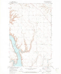
1970 Map of Kiehns Coulee
USGS Topo · Published 1973About this map
The impounded waters of the Fresno Reservoir dominate the western edge of this 1970 landscape, where the Milk River valley meets a network of rugged coulees. This survey, part of the Missouri River Basin development program, illustrates the mid-century infrastructure required for Northern Montana agriculture, including a Pumping Sta, an Aqueduct, and a significant Spillway near the reservoir's southern reach. On the higher prairie to the east, the rural social fabric is evidenced by the Grainbelt Sch situated along Flagstaff Road. The terrain is deeply incised by family-named drainage features like Carske Coulee, Messerschmidt Coulee, and Kiehns Coulee, which define the drainage patterns feeding into Kremlin Bay. A few remote Landing Strips emphasize the isolation and scale of these Hill County ranchlands during the early 1970s.
Find a feature on this map
19 named features on this map. Tap any name to fly to it.
Don’t see what you’re looking for? This feature index may not catch every label — zoom into the map to look around manually.
Map Details
Editions of this 1970 Kiehns Coulee Map
This is the sole edition of this map. No revisions or reprints were ever made.
Other maps of this area

1904 · Assinniboine
USGS Topo · 1:62,500

1906 · Kremlin
USGS Topo · 1:62,500

1912 · Thibedeau Lake
USGS Topo · 1:125,000

1920 · Gildford
USGS Topo · 1:125,000

1943 · Gildford
USGS Topo · 1:125,000

1953 · Havre
USGS Topo · 1:250,000

1954 · Shelby
USGS Topo · 1:250,000

1957 · Havre
USGS Topo · 1:250,000

1958 · Shelby
USGS Topo · 1:250,000

1958 · Havre
USGS Topo · 1:250,000