
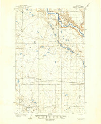
1906 Map of Kremlin
USGS Topo · Published 1906About this map
The Milk River meanders across this northern Montana landscape, carved by deep coulees and punctuated by isolated frontier outposts. This 1904 survey by William Stranahan documents a transition period for the Chouteau County ranching economy, where established spreads like Connollys Ranch and Holdens Ranch operated alongside a developing transportation corridor. The Great Northern R R cuts a straight line across the plains, anchoring small railroad stops at Kremlin and Xenia.
Find a feature on this map
21 named features on this map. Tap any name to fly to it.
Don’t see what you’re looking for? This feature index may not catch every label — zoom into the map to look around manually.
Map Details
Editions of this 1906 Kremlin Map
2 editions found
Other maps of this area

1904 · Assinniboine
USGS Topo · 1:62,500

1904 · Boxelder
USGS Topo · 1:62,500

1906 · Boxelder
USGS Topo · 1:62,500

1912 · Thibedeau Lake
USGS Topo · 1:125,000

1919 · Big Sandy
USGS Topo · 1:125,000

1920 · Gildford
USGS Topo · 1:125,000

1943 · Gildford
USGS Topo · 1:125,000

1953 · Havre
USGS Topo · 1:250,000

1954 · Shelby
USGS Topo · 1:250,000

1957 · Havre
USGS Topo · 1:250,000