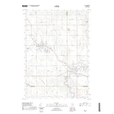
2018 Map of Kiel
USGS Topo · Published 2018About this map
New Holstein and Kiel serve as the primary hubs in this region of eastern Wisconsin, where the borders of Calumet, Manitowoc, and Sheboygan Counties converge. The landscape is defined by the winding course of the Sheboygan River and the expansive wetlands of Hayton Marsh to the north. Smaller settlements such as Meggers, Steinthal, and Saint Anna are scattered throughout the agricultural terrain, often centered around local landmarks and family histories.
Find a feature on this map
117 named features on this map. Tap any name to fly to it.
Don’t see what you’re looking for? This feature index may not catch every label — zoom into the map to look around manually.
Map Details
Editions of this 2018 Kiel Map
This is the sole edition of this map. No revisions or reprints were ever made.
Other maps of this area
1954 · School Hill
USGS Topo · 1:24,000
1954 · Howards Grove
USGS Topo · 1:62,500
1954 · Chilton
USGS Topo · 1:62,500
1954 · Reedsville
USGS Topo · 1:62,500
1954 · Franklin
USGS Topo · 1:24,000
1954 · Kiel
USGS Topo · 1:62,500

1954 · Milwaukee
USGS Topo · 1:250,000

1954 · Manitowoc
USGS Topo · 1:250,000

1955 · Green Bay
USGS Topo · 1:250,000

1957 · Madison
USGS Topo · 1:250,000