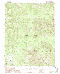
1985 Map of Kigalia Point
USGS Topo · Published 1985About this map
Manti-La Sal National Forest lands dominate this high-plateau landscape, where the massive geological divide of Elk Ridge and South Elk Ridge splits the drainage of southeastern Utah. This 1985 survey illustrates a wilderness defined by its dramatic verticality, from the towering height of Kigalia Point to the deep incisions of Dark Canyon and Hammond Canyon. The importance of water in this arid environment is evident through the inclusion of remote sites like Squaw Water Spring and Squaw Water Hole. Historically significant landmarks, including the notable Keystone Arch and the high grazing grounds of Babylon Pasture, provide essential reference points for understanding the early navigational and pastoral use of the San Juan back country.
Find a feature on this map
21 named features on this map. Tap any name to fly to it.
Don’t see what you’re looking for? This feature index may not catch every label — zoom into the map to look around manually.
Map Details
Editions of this 1985 Kigalia Point Map
This is the sole edition of this map. No revisions or reprints were ever made.
Other maps of this area

1886 · Abajo
USGS Topo · 1:250,000

1892 · Abajo
USGS Topo · 1:250,000

1893 · Abajo
USGS Topo · 1:250,000

1935 · Elk Ridge
USGS Topo · 1:96,000

1940 · Elk Ridge
USGS Topo · 1:125,000

1954 · Elk Ridge 4 NW
USGS Topo · 1:24,000

1954 · Elk Ridge 1 SW
USGS Topo · 1:24,000

1954 · Elk Ridge 2 SE
USGS Topo · 1:24,000
1954 · Elk Ridge 3 SW
USGS Topo · 1:24,000

1954 · Elk Ridge 3 NE
USGS Topo · 1:24,000