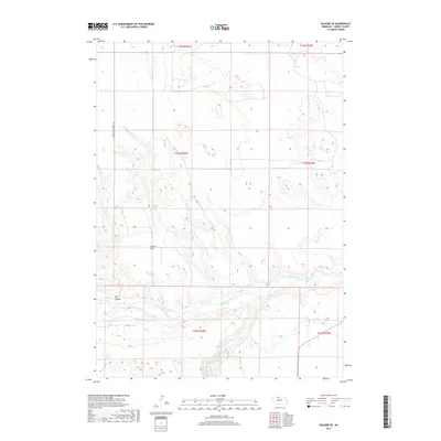
2017 Map of Kilgore SE
USGS Topo · Published 2017About this map
The Niobrara River carves a complex system of breaks and drainages across this northern Nebraska landscape, defining the topography of southern Cherry County. The river valley is joined by the Snake River in the south-central portion of the map, creating a network of deep-cut terrain including Cox Canyon. Above these watercourses, the high tablelands feature open landmarks like Church Flat, illustrating the contrast between the river-bottom ecology and the expansive Sandhills plateaus. For those researching local heritage, German Settlement Rd runs along the western edge of the quadrangle, preserving the name of early community centers in this sparsely populated cattle country. The map clearly delineates the township and range boundaries, such as t33n r30w and t32n r30w, which provide essential structure for property research and land-grant history in the region.
Find a feature on this map
11 named features on this map. Tap any name to fly to it.
Don’t see what you’re looking for? This feature index may not catch every label — zoom into the map to look around manually.
Map Details
Editions of this 2017 Kilgore SE Map
This is the sole edition of this map. No revisions or reprints were ever made.
Other maps of this area

1950 · Simeon
USGS Topo · 1:62,500

1950 · Kennedy
USGS Topo · 1:62,500

1950 · Kilgore
USGS Topo · 1:62,500

1950 · Valentine
USGS Topo · 1:62,500

1957 · Valentine
USGS Topo · 1:250,000

1959 · Valentine
USGS Topo · 1:250,000
1983 · Crookston East
USGS Topo · 1:24,000

1983 · Valentine SW
USGS Topo · 1:24,000
1985 · Kilgore SE
USGS Topo · 1:24,000

1985 · Cooper Canyon
USGS Topo · 1:24,000