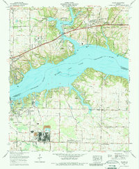
1971 Map of Killen
USGS Topo · Published 1991About this map
Wilson Dam anchors this landscape at the confluence of the Tennessee River (Wilson Lake) and Shoal Creek, marking a period of significant hydroelectric and industrial development on the border of Lauderdale and Colbert Counties. The map reveals the sprawling influence of the Tennessee Valley Authority, with industrial sites like Nitrate City and Listerhill situated south of the river near the Southern Railway tracks. To the north, the shoreline of Wilson Lake Shores and Virginia Shores indicates a transition toward recreational and residential growth, featuring landmarks such as the Turtle Point Yacht and Country Club. For genealogists, the survey identifies numerous small burial grounds and rural institutions, including the Old Brick Ch Cem, Hennigan Cem, and Whitmore Cem, alongside local gathering places like the Camp Hillcrest (YMCA).
Find a feature on this map
80 named features on this map. Tap any name to fly to it.
Don’t see what you’re looking for? This feature index may not catch every label — zoom into the map to look around manually.
Map Details
Editions of this 1971 Killen Map
3 editions found
Other maps of this area

1914 · Rogersville
USGS Topo · 1:48,000

1914 · Muscle Shoals
USGS Topo · 1:48,000

1916 · Muscle Shoals
USGS Topo · 1:62,500

1916 · Rogersville
USGS Topo · 1:62,500

1924 · Tuscumbia
USGS Topo · 1:48,000

1926 · Tuscumbia
USGS Topo · 1:62,500

1936 · Pruitton
USGS Topo · 1:24,000

1936 · Wheeler Dam
USGS Topo · 1:24,000

1936 · Florence
USGS Topo · 1:24,000

1936 · Town Creek
USGS Topo · 1:24,000