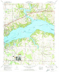
1971 Map of Killen
USGS Topo · Published 1973About this map
The Tennessee River corridor in the early 1970s is dominated by the expansive waters of Wilson Lake and the industrial infrastructure of the Tennessee Valley Authority. This era shows a landscape transitioning from rural agricultural roots to a modern power and industrial hub, anchored by the Wilson Dam and the sprawling chemical and filtration plants near Listerhill. While the town of Killen serves as a primary inland settlement, the shoreline is dotted with mid-century residential developments such as Edgewater Beach and Virginia Shores.
Find a feature on this map
82 named features on this map. Tap any name to fly to it.
Don’t see what you’re looking for? This feature index may not catch every label — zoom into the map to look around manually.
Map Details
Editions of this 1971 Killen Map
3 editions found
Other maps of this area

1914 · Rogersville
USGS Topo · 1:48,000

1914 · Muscle Shoals
USGS Topo · 1:48,000

1916 · Muscle Shoals
USGS Topo · 1:62,500

1916 · Rogersville
USGS Topo · 1:62,500

1924 · Tuscumbia
USGS Topo · 1:48,000

1926 · Tuscumbia
USGS Topo · 1:62,500

1936 · Pruitton
USGS Topo · 1:24,000

1936 · Wheeler Dam
USGS Topo · 1:24,000

1936 · Florence
USGS Topo · 1:24,000

1936 · Town Creek
USGS Topo · 1:24,000