
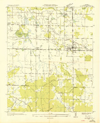
1936 Map of Town Creek
USGS Topo · Published 1936About this map
Town Creek serves as the central hub of this 1936 survey, where the Southern railroad and Joe Wheeler Highway intersect to define the local economy and movement. The map captures the rural landscape at a time when infrastructure was being transformed by the Tennessee Valley Authority, evidenced by the prominent Alabama Tennessee Power Valley Company Authority Transmission Line cutting across the terrain.
Find a feature on this map
31 named features on this map. Tap any name to fly to it.
Don’t see what you’re looking for? This feature index may not catch every label — zoom into the map to look around manually.
Map Details
Editions of this 1936 Town Creek Map
This is the sole edition of this map. No revisions or reprints were ever made.
Other maps of this area

1914 · Rogersville
USGS Topo · 1:48,000

1914 · Muscle Shoals
USGS Topo · 1:48,000

1916 · Muscle Shoals
USGS Topo · 1:62,500

1916 · Rogersville
USGS Topo · 1:62,500

1924 · Tuscumbia
USGS Topo · 1:48,000

1926 · Tuscumbia
USGS Topo · 1:62,500

1936 · Thorntontown
USGS Topo · 1:24,000

1936 · Courtland
USGS Topo · 1:24,000

1936 · Wheeler Dam
USGS Topo · 1:24,000
1936 · Leighton
USGS Topo · 1:24,000