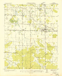
1936 Map of Leighton
USGS Topo · Published 1936About this map
Leighton serves as the primary rail hub on this Tennessee Valley Authority advance sheet, situated at the intersection of the Southern Railway and the Joe Wheeler Highway State No 20. The landscape is defined by the sharp transition from the level terrain of the north to the rising elevation of Lagrange Mountain in the south. This 1936 survey documents a rural society organized around small family-named landmarks and local institutions, including the Lagrange Cem and several community schools like Sockwell Sch and Whiteoak Sch. The presence of Muscle Shoals Airport and a prominent Power Transmission Line running through the center of the sheet reflects the era's infrastructure expansion. Numerous depressions and sinks are visible, particularly near Gum Bottom and Aycock Pond, indicating the underlying karst topography characteristic of this part of Colbert County.
Find a feature on this map
36 named features on this map. Tap any name to fly to it.
Don’t see what you’re looking for? This feature index may not catch every label — zoom into the map to look around manually.
Map Details
Editions of this 1936 Leighton Map
This is the sole edition of this map. No revisions or reprints were ever made.
Other maps of this area

1914 · Rogersville
USGS Topo · 1:48,000

1914 · Muscle Shoals
USGS Topo · 1:48,000

1916 · Muscle Shoals
USGS Topo · 1:62,500

1916 · Rogersville
USGS Topo · 1:62,500

1924 · Tuscumbia
USGS Topo · 1:48,000

1926 · Tuscumbia
USGS Topo · 1:62,500

1936 · Russellville
USGS Topo · 1:24,000

1936 · Wheeler Dam
USGS Topo · 1:24,000

1936 · Florence
USGS Topo · 1:24,000

1936 · Town Creek
USGS Topo · 1:24,000