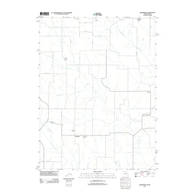
2012 Map of Kilwinning
USGS Topo · Published 2012About this map
Lister Cemetery and Sacred Heart Cemetery sit within the rural northern reaches of Scotland County, marking a landscape defined by the drainage basins of the South Wyaconda River and North Fabius River. This 2012 survey documents the agricultural character and scattered small settlements of the Missouri-Iowa border region, including the rural crossroads of Kilwinning and Hitt. The distribution of civic and family landmarks, such as Pleasant Hill Community Hall and Four Corners Community Hall, indicates a community structure centered on localized gathering points and small-scale creek systems like Brush Creek and Carter Creek. This era of the landscape is characterized by a grid of local roads, such as Pike Blvd and Quinine Ave, which connect long-established family burial grounds including Cone Cemetery and Kilwinning Cemetery.
Find a feature on this map
30 named features on this map. Tap any name to fly to it.
Don’t see what you’re looking for? This feature index may not catch every label — zoom into the map to look around manually.
Map Details
Editions of this 2012 Kilwinning Map
This is the sole edition of this map. No revisions or reprints were ever made.
Other maps of this area

1903 · Edina
USGS Topo · 1:125,000

1954 · Centerville
USGS Topo · 1:250,000

1957 · Centerville
USGS Topo · 1:250,000

1958 · Centerville
USGS Topo · 1:250,000

1965 · Memphis
USGS Topo · 1:24,000

1965 · Downing NW
USGS Topo · 1:24,000

1966 · Downing
USGS Topo · 1:24,000
1970 · Brock
USGS Topo · 1:24,000
1970 · Milton
USGS Topo · 1:24,000
1979 · Pulaski
USGS Topo · 1:24,000