
1965 Map of Memphis
USGS Topo · Published 1966About this map
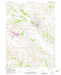
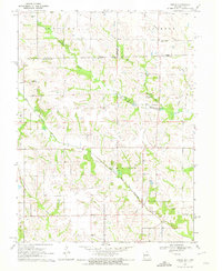
Memphis serves as the focal point of this mid-1960s survey, situated along the Chicago Burlington and Quincy rail line in Scotland County. The town's local infrastructure is well-defined, including the High Sch, Waterworks, and the County Fairground to the west. The surrounding rural landscape is shaped by the winding North Fork Fabius River and several smaller tributaries like Gunn Branch and Indian Creek. Numerous rural landmarks provide valuable points for genealogy and local history research, such as Oakridge Ch, Antioch Ch, and the Clark Cem. To the southwest of the town center, the Memphis Reservoir and Memphis Country Club indicate the development of local recreation, while the Memphis-Schenck Airstrip marks a point of private aviation history north of the river. The southern portion of the quadrangle transitions into the Sand Hill terrain near Concord Cem.
Find a feature on this map
25 named features on this map. Tap any name to fly to it.
Don’t see what you’re looking for? This feature index may not catch every label — zoom into the map to look around manually.
Map Details
Editions of this 1965 Memphis Map
2 editions found
Other maps of this area

1903 · Edina
USGS Topo · 1:125,000

1954 · Centerville
USGS Topo · 1:250,000

1957 · Centerville
USGS Topo · 1:250,000

1958 · Centerville
USGS Topo · 1:250,000
1965 · Rutledge
USGS Topo · 1:24,000
1965 · Arbela
USGS Topo · 1:24,000

1965 · Greensburg
USGS Topo · 1:24,000

1966 · Downing
USGS Topo · 1:24,000
1966 · Bible Grove
USGS Topo · 1:24,000
1970 · Brock
USGS Topo · 1:24,000