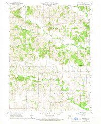
1966 Map of Bible Grove
USGS Topo · Published 1967About this map
Bible Grove and the surrounding farm country are documented here in the mid-1960s, showing a landscape defined by the branching tributaries of the Fabius River system. The settlement of Bible Grove sits near a marked Cem, while further south, Adair marks the lower portion of the sheet. This rural region is organized by several large townships, including Mount Pleasant, Independence, Clay, and Greensburg, which span the borders of Scotland, Adair, and Knox Counties.
Find a feature on this map
20 named features on this map. Tap any name to fly to it.
Don’t see what you’re looking for? This feature index may not catch every label — zoom into the map to look around manually.
Map Details
Editions of this 1966 Bible Grove Map
This is the sole edition of this map. No revisions or reprints were ever made.
Other maps of this area

1903 · Edina
USGS Topo · 1:125,000

1954 · Centerville
USGS Topo · 1:250,000

1957 · Centerville
USGS Topo · 1:250,000

1958 · Centerville
USGS Topo · 1:250,000

1965 · Memphis
USGS Topo · 1:24,000
1965 · Edina
USGS Topo · 1:24,000

1965 · Greensburg
USGS Topo · 1:24,000

1965 · Downing NW
USGS Topo · 1:24,000

1966 · Brashear
USGS Topo · 1:24,000

1966 · Downing
USGS Topo · 1:24,000