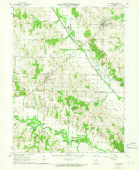
1965 Map of Rutledge
USGS Topo · Published 1966About this map
The Atchison Topeka and Santa Fe railroad serves as the primary industrial artery of this landscape, connecting the rural centers of Rutledge and Gorin (South Gorin) during the mid-1960s. These settlements, alongside the small community of Millport to the south, represent the agricultural heart of the region where the Scotland Co Knox Co line divides the terrain. The topography is defined by the winding paths of the North Fabius River and Middle Fabius River, which have shaped the settlement patterns of townships like Harrison, Benton, and Colony. Local history is deeply etched into the countryside through numerous family and community landmarks, such as Harmony Grove Ch and various burial grounds including Pauline Cem and Sand Hill Cem. Distinctive private aviation features like Wifeys Air Strip highlight the late-century evolution of these rural Missouri homesteads.
Find a feature on this map
22 named features on this map. Tap any name to fly to it.
Don’t see what you’re looking for? This feature index may not catch every label — zoom into the map to look around manually.
Map Details
Editions of this 1965 Rutledge Map
This is the sole edition of this map. No revisions or reprints were ever made.
Other maps of this area

1903 · Kahoka
USGS Topo · 1:125,000

1903 · Edina
USGS Topo · 1:125,000

1950 · Colony
USGS Topo · 1:24,000

1951 · Colony
USGS Topo · 1:24,000

1951 · Wyaconda
USGS Topo · 1:24,000
1951 · Deer Ridge
USGS Topo · 1:24,000

1954 · Centerville
USGS Topo · 1:250,000

1957 · Centerville
USGS Topo · 1:250,000

1958 · Centerville
USGS Topo · 1:250,000

1958 · Burlington
USGS Topo · 1:250,000