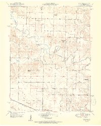
1951 Map of Deer Ridge
USGS Topo · Published 1951About this map
The Middle Fabius River carves a winding path through the borderlands of Knox and Lewis counties, defining a landscape of traditional rural education and agriculture. In the early 1950s, this region was undergoing a significant shift in its social geography, evidenced by several schoolhouses already marked as out of use, including Union Sch, Deer Ridge Sch, and Banner Sch. These markers of consolidation stand in contrast to active community hubs like Forest Springs and Deer Ridge.
Find a feature on this map
31 named features on this map. Tap any name to fly to it.
Don’t see what you’re looking for? This feature index may not catch every label — zoom into the map to look around manually.
Map Details
Editions of this 1951 Deer Ridge Map
3 editions found
Other maps of this area

1903 · Kahoka
USGS Topo · 1:125,000

1903 · Edina
USGS Topo · 1:125,000

1950 · Neeper
USGS Topo · 1:24,000

1950 · Williamstown
USGS Topo · 1:24,000

1950 · Lewistown
USGS Topo · 1:24,000

1950 · Colony
USGS Topo · 1:24,000

1950 · La Belle
USGS Topo · 1:24,000

1951 · La Belle
USGS Topo · 1:24,000

1951 · Colony
USGS Topo · 1:24,000

1951 · Neeper
USGS Topo · 1:24,000