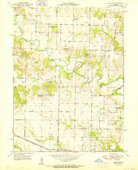
1951 Map of Deer Ridge
USGS Topo · Published 1951About this map
The Middle Fabius River winds through the heart of northern Lewis County, defining the landscape with its dramatic oxbow at Horseshoe Bend. In the early 1950s, this area near the Knox County line was characterized by a dense network of local schools and churches that served a predominantly rural population. Small hubs like Forest Springs and the village of Deer Ridge provided local focal points, while the Chicago Burlington and Quincy railroad cut across the southern edge of the sheet, providing a vital link to larger markets.
Find a feature on this map
34 named features on this map. Tap any name to fly to it.
Don’t see what you’re looking for? This feature index may not catch every label — zoom into the map to look around manually.
Map Details
Editions of this 1951 Deer Ridge Map
3 editions found
Other maps of this area

1903 · Kahoka
USGS Topo · 1:125,000

1903 · Edina
USGS Topo · 1:125,000

1950 · Neeper
USGS Topo · 1:24,000

1950 · Williamstown
USGS Topo · 1:24,000

1950 · Lewistown
USGS Topo · 1:24,000

1950 · Colony
USGS Topo · 1:24,000

1950 · La Belle
USGS Topo · 1:24,000

1951 · La Belle
USGS Topo · 1:24,000

1951 · Colony
USGS Topo · 1:24,000

1951 · Neeper
USGS Topo · 1:24,000