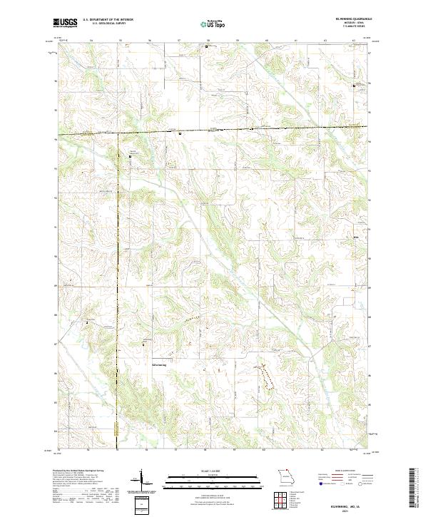
2021 Map of Kilwinning
USGS Topo · Published 2021About this map
The N Fork Fabius River and S Wyaconda River shape the rural landscape along the border of Iowa and Missouri. This area, spanning Scotland and Schuyler counties in Missouri and Davis County in Iowa, is defined by its small farming communities and a network of gravel roads. The settlement of Kilwinning serves as a central point in the southern half of the quadrangle, while Hitt anchors the eastern edge. Local genealogy is deeply etched into the land through numerous family and community burial grounds, including Lister Cem, Barker Cem, and the Kilwinning Cem. The topography is a complex system of drainage, with smaller tributaries like Carter Cr, Brush Cr, and Pony Cr carving through the agricultural sections. The presence of Sacred Heart Cem and Cone Cem further highlights the long-established rural parishes that have occupied these borderlands for generations.
Find a feature on this map
48 named features on this map. Tap any name to fly to it.
Don’t see what you’re looking for? This feature index may not catch every label — zoom into the map to look around manually.
Map Details
Editions of this 2021 Kilwinning Map
This is the sole edition of this map. No revisions or reprints were ever made.
Other maps of this area

1903 · Edina
USGS Topo · 1:125,000

1954 · Centerville
USGS Topo · 1:250,000

1957 · Centerville
USGS Topo · 1:250,000

1958 · Centerville
USGS Topo · 1:250,000

1965 · Memphis
USGS Topo · 1:24,000

1965 · Downing NW
USGS Topo · 1:24,000

1966 · Downing
USGS Topo · 1:24,000
1970 · Brock
USGS Topo · 1:24,000
1970 · Milton
USGS Topo · 1:24,000
1979 · Pulaski
USGS Topo · 1:24,000