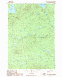
1989 Map of Kind And Bartlett Lake
USGS Topo · Published 1989About this map
Spencer Lake and King and Bartlett Lake dominate this remote northern landscape, which remained largely defined by its original township survey boundaries into the late twentieth century. This 1989 provisional survey reveals a terrain shaped by the waters of Spencer Stream and Little Spencer Stream, punctuated by the white water of Gore Rapids and the narrow passage of Spencer Gut. The map documents the intricate drainage network of the Somerset backwoods, including Parker Pond, Shaw Pond, and the wetlands of Pokum Bog. Beyond the waterways, prominent elevations like Bear Mountain, Black Nubble, and Little King Ridge overlook the timberlands. While primarily a natural expanse, the inclusion of a Gravel Pit and several unnamed unimproved roads indicates the ongoing role of resource management and local infrastructure in this unorganized territory.
Find a feature on this map
31 named features on this map. Tap any name to fly to it.
Don’t see what you’re looking for? This feature index may not catch every label — zoom into the map to look around manually.
Map Details
Editions of this 1989 Kind And Bartlett Lake Map
2 editions found
Other maps of this area

1925 · Pierce Pond
USGS Topo · 1:48,000

1927 · Pierce Pond
USGS Topo · 1:62,500

1928 · Spencer
USGS Topo · 1:48,000

1928 · Dead River
USGS Topo · 1:62,500

1928 · Stratton
USGS Topo · 1:48,000

1931 · Dead River
USGS Topo · 1:48,000

1932 · Stratton
USGS Topo · 1:62,500

1932 · Spencer
USGS Topo · 1:62,500

1944 · Dead River
USGS Topo · 1:62,500

1944 · Pierce Pond
USGS Topo · 1:62,500
Featured Places
- Flagstaff Township, ME
- T3 R5 BKP WKR, ME
- Spring Lake Township, ME
- King & Bartlett Township, ME
- Somerset County, ME