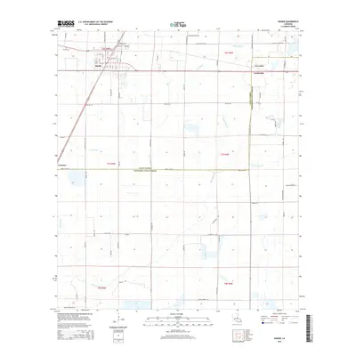
2015 Map of Kinder
USGS Topo · Published 2015About this map
Kinder serves as the primary hub in this southwest Louisiana landscape, where the town’s grid meets a network of rural routes and water management features. The area's agricultural and drainage history is evident through the presence of the Kinder Canal and Kinder Ditch, which cut through the level terrain alongside natural waterways like Bayou Serpent and Gum Bayou. Small settlements such as Fontenot, Coverdale, and Lauderdale are scattered across the parish lines, connected by family-named thoroughfares including Clyde Duplechaid Rd and Guillory Rd. The map also documents the Allen Parish and Jefferson Davis Parish boundary, which follows Parish Line Rd. Local heritage is anchored by sites like McGee Cem and landmarks accessed via Kinder Cemetery Rd, reflecting the generational footprint of families settled in this prairie and bayou region.
Find a feature on this map
70 named features on this map. Tap any name to fly to it.
Don’t see what you’re looking for? This feature index may not catch every label — zoom into the map to look around manually.
Map Details
Editions of this 2015 Kinder Map
This is the sole edition of this map. No revisions or reprints were ever made.
Other maps of this area

1947 · Kinder
USGS Topo · 1:31,680

1947 · Fenton
USGS Topo · 1:31,680

1947 · Oberlin
USGS Topo · 1:31,680

1947 · Pine Island
USGS Topo · 1:31,680

1947 · Le Blanc
USGS Topo · 1:31,680

1947 · Elton
USGS Topo · 1:31,680

1947 · Edna
USGS Topo · 1:31,680

1947 · Hathaway
USGS Topo · 1:31,680

1949 · Bayou Blue
USGS Topo · 1:31,680

1950 · Fenton
USGS Topo · 1:31,680