
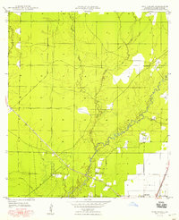
1949 Map of Bayou Blue
USGS Topo · Published 1949About this map
The Coushatta Indian Sch stands as a focal point for the Coushatta Tribe of Louisiana in this rural Allen Parish landscape during the mid-20th century. The territory is defined by an intricate network of waterways, including Bayou Blue and its tributaries like Cyrus Gully and Spring Coulee. These natural drainage patterns dictate the placement of roads and early industrial infrastructure.
Find a feature on this map
13 named features on this map. Tap any name to fly to it.
Don’t see what you’re looking for? This feature index may not catch every label — zoom into the map to look around manually.
Map Details
Editions of this 1949 Bayou Blue Map
This is the sole edition of this map. No revisions or reprints were ever made.
Other maps of this area

1947 · Kinder
USGS Topo · 1:31,680

1947 · Fruge Lake
USGS Topo · 1:31,680

1947 · Foley
USGS Topo · 1:31,680

1947 · Oberlin
USGS Topo · 1:31,680

1947 · Pine Chapel
USGS Topo · 1:31,680

1947 · Elton
USGS Topo · 1:31,680

1947 · Bond
USGS Topo · 1:31,680

1947 · Basile
USGS Topo · 1:31,680
1948 · Pine Chapel
USGS Topo · 1:24,000

1949 · Basile
USGS Topo · 1:31,680