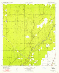
1948 Map of Pine Chapel
USGS Topo · Published 1948About this map
The Calcasieu River meanders through the heart of this post-war landscape, shaping the development of Louisiana's Allen Parish. While the southern edge is anchored by the settlement of Oberlin, the surrounding countryside is defined by the legacy of the timber industry and rural community life. An Old Railroad Grade and the Missouri Pacific line suggest the area's historical dependence on rail transport for moving local resources through the piney woods. Scattered settlements like Pine Chapel and Oakland Springs Ch provide evidence of early local religious and social centers, while the Oberlin Lookout stands as a sentinel over the forest. Numerous waterways, including Tenmile Creek, Mill Creek, and Chinquapin Creek, converge toward the river, creating a complex drainage network that influenced early road placement and land use before mid-century modernizations reached this part of the state.
Find a feature on this map
12 named features on this map. Tap any name to fly to it.
Don’t see what you’re looking for? This feature index may not catch every label — zoom into the map to look around manually.
Map Details
Editions of this 1948 Pine Chapel Map
This is the sole edition of this map. No revisions or reprints were ever made.
Other maps of this area

1935 · Mittie
USGS Topo · 1:31,680

1935 · Oakdale
USGS Topo · 1:31,680

1942 · Oakdale
USGS Topo · 1:62,500

1947 · Foley
USGS Topo · 1:31,680

1947 · Oberlin
USGS Topo · 1:31,680

1947 · Pine Chapel
USGS Topo · 1:31,680

1947 · Le Blanc
USGS Topo · 1:31,680

1947 · Elizabeth
USGS Topo · 1:31,680

1947 · Grant
USGS Topo · 1:31,680

1948 · Grant
USGS Topo · 1:24,000