
1947 Map of Fruge Lake
USGS Topo · Published 1947About this map
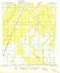
Nezpique Bayou meanders through the heart of this landscape, defining the boundary between Allen and Evangeline Parishes during the mid-1930s. The area is characterized by its intricate water network, featuring Fruge Lake and numerous bayous like Grand Louis Bayou and Duralde Bayou. Evidence of the region's timber history is visible in the Old Logging Railroad Grade, which cuts through the central sections, marking a transition from active industry to a rural agricultural and homesteading phase. Small communities and family-named locations such as Hampton and Veillon anchor the northern reaches. The social fabric of the era is preserved through the specific locations of rural schoolhouses, including La Fleur Sch, Veillon Sch, Valentine Sch, and Fruge Sch, which served the scattered families living along the bayou banks and newly established roads.
Find a feature on this map
18 named features on this map. Tap any name to fly to it.
Don’t see what you’re looking for? This feature index may not catch every label — zoom into the map to look around manually.
Map Details
Editions of this 1947 Fruge Lake Map
This is the sole edition of this map. No revisions or reprints were ever made.
Other maps of this area

1947 · Foley
USGS Topo · 1:31,680

1947 · Redland
USGS Topo · 1:31,680

1947 · Elton
USGS Topo · 1:31,680

1947 · Bond
USGS Topo · 1:31,680

1947 · Eunice
USGS Topo · 1:31,680

1947 · Basile
USGS Topo · 1:31,680

1949 · Bayou Blue
USGS Topo · 1:31,680

1949 · Basile
USGS Topo · 1:31,680
1950 · Foley
USGS Topo · 1:31,680
1951 · Guy
USGS Topo · 1:24,000