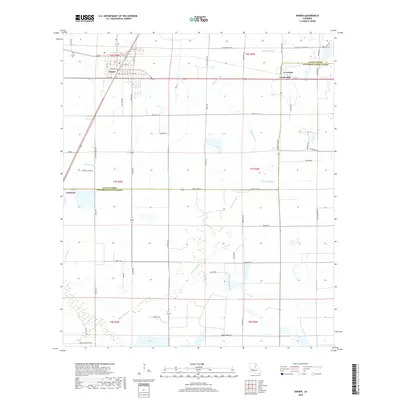
2018 Map of Kinder
USGS Topo · Published 2018About this map
Kinder serves as the primary hub in this portion of Allen Parish, situated at the intersection of several major regional routes including 190, 165, and 383. The town's grid is clearly defined by numbered streets and avenues, while the surrounding landscape is marked by a complex system of waterways and drainage. To the east, the smaller settlements of Coverdale and Lauderdale sit along the parish line, while Fontenot is positioned to the west. The territory is characterized by significant natural and engineered water features, notably Bayou Serpent and Bayou Alligator, alongside agricultural infrastructure like the Kinder Ditch and Kinder Canal. For those tracing local family history, the McGee Cem provides a specific point of interest in the northwestern section of the township. The boundary between Allen Parish and Jefferson Davis Parish cuts directly through the lower third of the quadrangle, dividing the rural landscape.
Find a feature on this map
76 named features on this map. Tap any name to fly to it.
Don’t see what you’re looking for? This feature index may not catch every label — zoom into the map to look around manually.
Map Details
Editions of this 2018 Kinder Map
This is the sole edition of this map. No revisions or reprints were ever made.
Other maps of this area

1947 · Kinder
USGS Topo · 1:31,680

1947 · Fenton
USGS Topo · 1:31,680

1947 · Oberlin
USGS Topo · 1:31,680

1947 · Pine Island
USGS Topo · 1:31,680

1947 · Le Blanc
USGS Topo · 1:31,680

1947 · Elton
USGS Topo · 1:31,680

1947 · Edna
USGS Topo · 1:31,680

1947 · Hathaway
USGS Topo · 1:31,680

1949 · Bayou Blue
USGS Topo · 1:31,680

1950 · Fenton
USGS Topo · 1:31,680