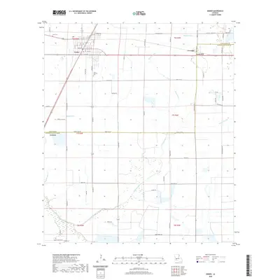
2020 Map of Kinder
USGS Topo · Published 2020About this map
Kinder serves as the primary hub for this section of Southwest Louisiana, situated at the junction of 190 and 165. The town's grid is well-defined, stretching from 1st Ave up to Kennedy Ave. The surrounding landscape is heavily marked by the irrigation and drainage infrastructure required for local agriculture, including the prominent Kinder Canal and Kinder Ditch. These man-made features weave through the natural drainage of Bayou Serpent and Bayou Alligator, reflecting the region's managed wetlands and prairies. Farther east, the small communities of Coverdale and Lauderdale sit along the parish boundary. For genealogists, the map identifies several local burial sites, such as McGee Cem northwest of town and Carter Memorial Cem to the south. The presence of numerous numbered parish roads and local routes like Eloi Ortego Rd illustrates the rural connectivity of Allen Parish and Jefferson Davis Parish in the modern era.
Find a feature on this map
80 named features on this map. Tap any name to fly to it.
Don’t see what you’re looking for? This feature index may not catch every label — zoom into the map to look around manually.
Map Details
Editions of this 2020 Kinder Map
This is the sole edition of this map. No revisions or reprints were ever made.
Other maps of this area

1947 · Kinder
USGS Topo · 1:31,680

1947 · Fenton
USGS Topo · 1:31,680

1947 · Oberlin
USGS Topo · 1:31,680

1947 · Pine Island
USGS Topo · 1:31,680

1947 · Le Blanc
USGS Topo · 1:31,680

1947 · Elton
USGS Topo · 1:31,680

1947 · Edna
USGS Topo · 1:31,680

1947 · Hathaway
USGS Topo · 1:31,680

1949 · Bayou Blue
USGS Topo · 1:31,680

1950 · Fenton
USGS Topo · 1:31,680