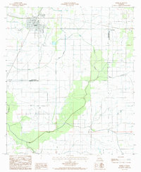
1985 Map of Kinder
USGS Topo · Published 1985About this map
Kinder serves as the primary hub of this Southwest Louisiana landscape, where the Missouri Pacific railroad intersects with major regional thoroughfares like Route 165 and Route 190. The area is defined by its extensive agricultural infrastructure, particularly the Kinder Irrigation Canal and a dense network of flumes and ditches that supported local rice farming. Small communities and family-named locales such as Lauderdale and Fontenot sit within the prairie, while the natural drainage of Bayou Serpent and Alligator Bayou meanders through the eastern and southern portions of the quadrangle. For those researching local heritage, the map identifies several Cem sites and prominent landmarks like a Radio Tower near the Allen and Jefferson Davis Parish boundary, reflecting the region's mid-1980s transition toward modernized utility and transport networks, including a prominent Steel Tower Powerline.
Find a feature on this map
16 named features on this map. Tap any name to fly to it.
Don’t see what you’re looking for? This feature index may not catch every label — zoom into the map to look around manually.
Map Details
Editions of this 1985 Kinder Map
This is the sole edition of this map. No revisions or reprints were ever made.
Other maps of this area

1947 · Kinder
USGS Topo · 1:31,680

1947 · Fenton
USGS Topo · 1:31,680

1947 · Oberlin
USGS Topo · 1:31,680

1947 · Pine Island
USGS Topo · 1:31,680

1947 · Le Blanc
USGS Topo · 1:31,680

1947 · Elton
USGS Topo · 1:31,680

1947 · Edna
USGS Topo · 1:31,680

1947 · Hathaway
USGS Topo · 1:31,680

1949 · Bayou Blue
USGS Topo · 1:31,680

1950 · Fenton
USGS Topo · 1:31,680