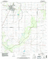
1994 Map of Kinder
USGS Topo · Published 1996About this map
Kinder serves as the primary hub of this Southwest Louisiana landscape, positioned just north of the Allen Parish Jefferson Davis Parish boundary. The area is defined by a complex network of water management and natural drainage, with the prominent Kinder Irrigation Canal cutting across the terrain to support local agricultural needs. Further east, the small settlement of Lauderdale sits near the parish line, while Fontenot marks the western reaches of the quadrangle.
Find a feature on this map
14 named features on this map. Tap any name to fly to it.
Don’t see what you’re looking for? This feature index may not catch every label — zoom into the map to look around manually.
Map Details
Editions of this 1994 Kinder Map
This is the sole edition of this map. No revisions or reprints were ever made.
Other maps of this area

1947 · Kinder
USGS Topo · 1:31,680

1947 · Fenton
USGS Topo · 1:31,680

1947 · Oberlin
USGS Topo · 1:31,680

1947 · Pine Island
USGS Topo · 1:31,680

1947 · Le Blanc
USGS Topo · 1:31,680

1947 · Elton
USGS Topo · 1:31,680

1947 · Edna
USGS Topo · 1:31,680

1947 · Hathaway
USGS Topo · 1:31,680

1949 · Bayou Blue
USGS Topo · 1:31,680

1950 · Fenton
USGS Topo · 1:31,680