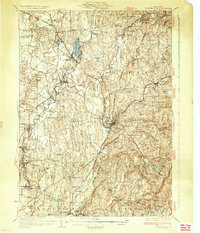
1933 Map of Kinderhook
USGS Topo · Published 1933About this map
Kinderhook Creek and the Boston and Albany RR dictate the 1930s landscape of northern Columbia County, where traditional agriculture meets early industrial power. The map documents the historic Martin Van Buren Homestead and the Ichabod Crane Sch, underscoring the region's deep literary and political heritage. Along the waterways, drops in elevation support sites like Stuyvesant Falls and Chittenden Falls, while the Boston and Albany Highway threads through established villages including Valatie, Niverville, and Chatham. A dense network of local district schools, such as School No 6 and the Oak Ridge Sch, reveals a settled rural population organized around small crossroads. From the heights of Ashley Hill to the mineral waters of Columbia Sprs, the survey records a valley in a state of mature development before post-war suburbanization altered its character.
Find a feature on this map
79 named features on this map. Tap any name to fly to it.
Don’t see what you’re looking for? This feature index may not catch every label — zoom into the map to look around manually.
Map Details
Editions of this 1933 Kinderhook Map
3 editions found

Other maps of this area

1885 · Sheffield
USGS Topo · 1:62,500

1888 · Sheffield
USGS Topo · 1:62,500

1888 · Berlin
USGS Topo · 1:62,500

1888 · Pittsfield
USGS Topo · 1:62,500

1890 · Pittsfield
USGS Topo · 1:62,500

1890 · Berlin
USGS Topo · 1:62,500

1891 · Sheffield
USGS Topo · 1:62,500

1893 · Troy
USGS Topo · 1:62,500

1893 · Coxsackie
USGS Topo · 1:62,500

1893 · Sheffield
USGS Topo · 1:62,500