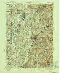
1933 Map of Kinderhook
USGS Topo · Published 1941About this map
Martin Van Buren Homestead anchors the western portion of this Columbia County landscape, situated just south of the village of Kinderhook. The area reflects a deeply established agricultural and early industrial corridor during the early 1930s, where water power from Kinderhook Creek and Valatie Creek supported multiple settlements such as Stuyvesant Falls and Chittenden Falls.
Find a feature on this map
81 named features on this map. Tap any name to fly to it.
Don’t see what you’re looking for? This feature index may not catch every label — zoom into the map to look around manually.
Map Details
Editions of this 1933 Kinderhook Map
3 editions found

Other maps of this area

1885 · Sheffield
USGS Topo · 1:62,500

1888 · Sheffield
USGS Topo · 1:62,500

1888 · Berlin
USGS Topo · 1:62,500

1888 · Pittsfield
USGS Topo · 1:62,500

1890 · Pittsfield
USGS Topo · 1:62,500

1890 · Berlin
USGS Topo · 1:62,500

1891 · Sheffield
USGS Topo · 1:62,500

1893 · Troy
USGS Topo · 1:62,500

1893 · Coxsackie
USGS Topo · 1:62,500

1893 · Sheffield
USGS Topo · 1:62,500