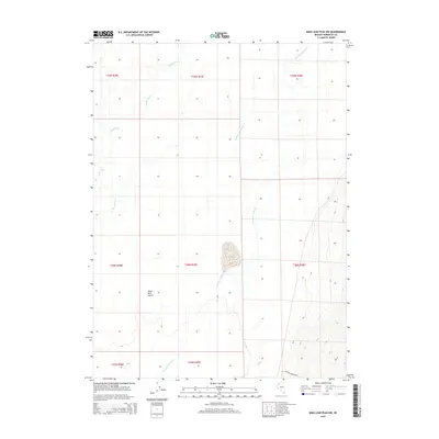
2015 Map of King Lear Peak NW
USGS Topo · Published 2015About this map
Black Rock Desert defines the western expanse of this high-desert landscape in Humboldt County, where the stark, flat playa meets the rising topography of the surrounding ranges. The braided channels of the Quinn River wind through the northern sections of the map, illustrating the ephemeral nature of water in this arid basin. This drainage system is further characterized by the intricate pathways of Jackson Cr Slough, which meanders across the central and southern flats. Settlement in this isolated region is represented by the Jackson Creek Rnch at the foot of the mountains to the southeast. The map clearly delineates the Public Land Survey System grid, showing the townships from T37N to T39N, providing a precise spatial framework for understanding land use and historical grazing patterns in this corner of the Great Basin.
Find a feature on this map
12 named features on this map. Tap any name to fly to it.
Don’t see what you’re looking for? This feature index may not catch every label — zoom into the map to look around manually.
Map Details
Editions of this 2015 King Lear Peak NW Map
This is the sole edition of this map. No revisions or reprints were ever made.
Other maps of this area

1886 · Disaster
USGS Topo · 1:250,000

1893 · Disaster
USGS Topo · 1:250,000

1954 · Vya
USGS Topo · 1:250,000

1958 · Vya
USGS Topo · 1:250,000

1962 · Vya
USGS Topo · 1:250,000

1966 · King Lear Peak
USGS Topo · 1:62,500

1972 · Pinto Mountain
USGS Topo · 1:24,000

1972 · Hobo Canyon
USGS Topo · 1:24,000
1972 · Leonard Cr. Slough South
USGS Topo · 1:24,000
1979 · Crowbar Spring
USGS Topo · 1:24,000